Garmin GB Discoverer v3.0 - national parks and trails 1:25K
Mon Oct 22, 2012 7:36 am
Garmin GB Discoverer v3.0 - national parks and trails 1:25K
Version: 3.00
Released: Sept, 2011
Explore Great Britain's national parks and trails with detailed topographic data, including terrain contours, topo elevations, summits, paths, routable roads and geographical points. This product has routable roads and points of interest from NAVTEQ and digital topographic OS Explorer Map as detailed as 1:25,000 scale and 1:50,000 scale Landranger maps for the 1 - 14.
MapID: 2543
GB Discoverer 50K v3.0 - Great Britain National Parks 1:50K
Version: 3.00
Released: Sept, 2011
Part Number: 010-C0988-00 (microSD/SD), 010-D0196-00 (Download)
Explore Great Britain's national parks with detailed topographic data, including terrain contours, topo elevations, summits, paths, routable roads and geographical points. This product has routable roads and points of interest from NAVTEQ and digital topographic maps of all of the national parks at 1:50,000 scale from Ordnance Survey of Great Britain.
MapID: 2543
Version: 3.00
Released: Sept, 2011
Explore Great Britain's national parks and trails with detailed topographic data, including terrain contours, topo elevations, summits, paths, routable roads and geographical points. This product has routable roads and points of interest from NAVTEQ and digital topographic OS Explorer Map as detailed as 1:25,000 scale and 1:50,000 scale Landranger maps for the 1 - 14.
MapID: 2543
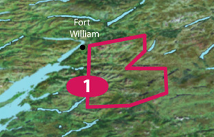
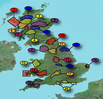
1. Ben Nevis and Glencoe (462MB)
Locked [Please Register or Login to download file]
UnLocked [Please Register or Login to download file]
About Coverage
Features topographic coverage of Fort William, Ben Nevis Range, Kinlochleven, Glencoe Range, Ben Starav and Bridge of Orchy.
- Code:
https://buy.garmin.com/en-US/US/prod33266.html
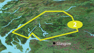
2. Loch Lomond and the Trossachs (512MB)
Locked [Please Register or Login to download file]
UnLocked [Please Register or Login to download file]
About Coverage
Features topographic coverage from Tyndrum to St Fillans; Benmore to Lochgoihead, to Arrochar, to Alexandria, to Callander.
- Code:
https://buy.garmin.com/en-US/US/prod33271.html
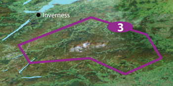
3. The Cairngorms (630MB)
Locked [Please Register or Login to download file]
UnLocked [Please Register or Login to download file]
About Coverage
Features topographic coverage of loops from Aviemore to Granton-on-Spey, to Mains of Dalvey, to Loch Knord, to Cairnwelly, to Dalwhinnie, to Newtonmore.
- Code:
https://buy.garmin.com/en-US/US/prod33296.html
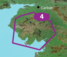
4. Lake District (524MB)
Locked [Please Register or Login to download file]
UnLocked [Please Register or Login to download file]
About Coverage
Features topographic coverage from Blind Crake to Askham; and Kirksanton to Lindale.
- Code:
https://buy.garmin.com/en-US/US/prod33287.html
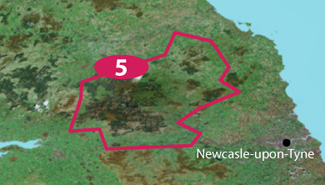
5. Northumberland (487MB)
Locked [Please Register or Login to download file]
UnLocked [Please Register or Login to download file]
About Coverage
Features topographic coverage from Kilham to Ingram; Catcleugh Reservoir to Rothbury Forest; and Gilsland to Walwick.
- Code:
https://buy.garmin.com/en-US/US/prod33281.html
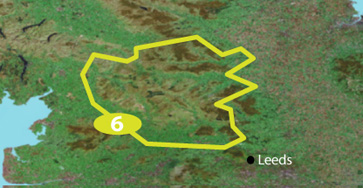
6. Yorkshire Dales (490MB)
Locked [Please Register or Login to download file]
UnLocked [Please Register or Login to download file]
About Coverage
Features topographic coverage of loops from Sedbergh to Langthwaite, to Barden, to Settle, to Ingleton.
- Code:
https://buy.garmin.com/en-US/US/prod33280.html
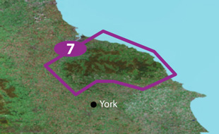
7. North Yorkshire Moors (467MB)
Locked [Please Register or Login to download file]
UnLocked [Please Register or Login to download file]
About Coverage
Features topographic coverage of loops from Mount Grace Priory to Guisborough, to Whitby, to East and West Ayton, to Pickering, to Coxwold.
- Code:
https://buy.garmin.com/en-US/US/prod33275.html
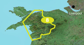
8. Snowdonia National Park (523MB)
Locked [Please Register or Login to download file]
UnLocked [Please Register or Login to download file]
About Coverage
Features topographic coverage of loops from Conwy to Bala, to Tywyn, to Porthmadog, to Llanberis, to Bangor.
- Code:
https://buy.garmin.com/en-US/US/prod33282.html
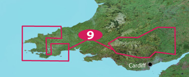
9. Brecon Beacons and Pembroke Coast (525MB)
Locked [Please Register or Login to download file]
UnLocked [Please Register or Login to download file]
About Coverage
Features topographic coverage of Pembrokeshire Coastal National Park from Cemaes Head to Amroth Castle; and Brecon Beacons National Park, looping from Llandovery to Hay-On-Wye, to Pontypool, to Glanaman.
- Code:
https://buy.garmin.com/en-US/US/prod33294.html
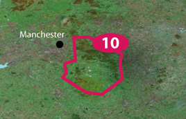
10. Peak District (491MB)
Locked [Please Register or Login to download file]
UnLocked [Please Register or Login to download file]
About Coverage
Features topographic coverage from Uppermill to Langsett; Meerbrook to Fenny Bentley, to Matlock Bridge.
- Code:
https://buy.garmin.com/en-US/US/prod33276.html
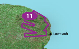
11. The Norfolk Broads (418MB)
Locked [Please Register or Login to download file]
UnLocked [Please Register or Login to download file]
About Coverage
Features topographic coverage of all of the Norfolk Broads from Honing to Oulton Dyke.
- Code:
https://buy.garmin.com/en-US/US/prod33259.html
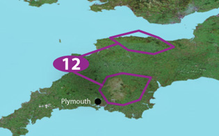
12. Dartmoor and Exmoor (482MB)
Locked [Please Register or Login to download file]
UnLocked [Please Register or Login to download file]
About Coverage
Features topographic coverage of Exmoor National Park from Combe Martin to Williton; North Molton to Dulverton, to Elworthy. Also includes Dartmoor National Park from Okehampton to Doddiscombsleigh; Tavistock to Ivybridge, to Buckfastleigh.
- Code:
https://buy.garmin.com/en-US/US/prod33277.html
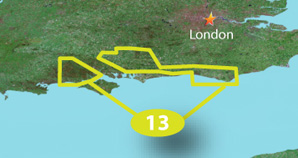
13. The New Forest and South Downs (550MB)
Locked [Please Register or Login to download file]
UnLocked [Please Register or Login to download file]
About Coverage
Features topographic coverage of all of the New Forest and South Down national parks from Winchester, to Alton, to Haslemere, to Pulborough, to the Seven Sisters.
- Code:
https://buy.garmin.com/en-US/US/prod33274.html
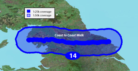
14. Coast to Coast Walk (731MB)
Locked [Please Register or Login to download file] [Please Register or Login to download file]
UnLocked [Please Register or Login to download file] [Please Register or Login to download file]
About Coverage
Features topographic coverage from St. Bees to Robin Hood's Bay.
- Code:
https://buy.garmin.com/en-US/US/prod33286.html
GB Discoverer 50K v3.0 - Great Britain National Parks 1:50K
Version: 3.00
Released: Sept, 2011
Part Number: 010-C0988-00 (microSD/SD), 010-D0196-00 (Download)
Explore Great Britain's national parks with detailed topographic data, including terrain contours, topo elevations, summits, paths, routable roads and geographical points. This product has routable roads and points of interest from NAVTEQ and digital topographic maps of all of the national parks at 1:50,000 scale from Ordnance Survey of Great Britain.
- Includes terrain contours, elevations, summits, trails, trig points, campsites, geographic points and more.
- Provides the same detailed road data used in our automotive products, with thousands of addresses and points of interest, including lodging, food and drink, car parks, banks, petrol stations, attractions, campsites and more.
- Includes Digital Elevation Model (DEM) for route profile planning
- Provides turn-by-turn directions on roads by car or bike.
- Allows user to search for destinations by address or by category: points of interest include lodging, food and drink, car parks, banks, petrol stations, attractions, campsites and more.
MapID: 2543
GB Discoverer 50K v3.0 - Great Britain National Parks 1:50K
Locked [Please Register or Login to download file] [Please Register or Login to download file] [Please Register or Login to download file]
UnLocked [Please Register or Login to download file] [Please Register or Login to download file] [Please Register or Login to download file]
About Coverage
Features 50K detail map coverage for all of these parks: Isle of Skye, North Highlands, Central Highlands, South Highlands, Ben Nevis and Glencoe, Loch Lomond and the Trossachs, Rannoch and Loch Tay, The Cairngorms, Lake District, Northumberland, Yorkshire Dales, North Yorkshire Moors, Snowdonia National Park, Brecon Beacons and Pembroke Coast, Peak District, The National Forest, The Cotswolds, The Norfolk Broads, Dartmoor and Exmoor, The New Forest and South Downs.
- Code:
https://buy.garmin.com/en-US/US/prod33284.html
Last edited by huntsman on Mon Jan 12, 2015 10:16 pm, edited 9 times in total.
GB Discoverer National Parks & Trails 1:25K v3.00
Sun Jan 27, 2013 6:03 pm
[color="#2F4F4F"]GB Discoverer National Parks & Trails 1:25K v3.00 (unlocked)[/color]
Version: 3.00
Released: September 2011
MapID: 2543
Mirrors @ NETuploaded.com (not really fast but never expire) & uploaded.net (ul.to)
All parts are compatible to the links above from huntsman
1 Ben Nevis and Glencoe (426MB)
[Please Register or Login to download file]
2. Loch Lomond and the Trossachs (512MB)
[Please Register or Login to download file]
3. The Cairngorms (630MB)
[Please Register or Login to download file]
4. Lake District (524MB)
[Please Register or Login to download file]
5. Northumberland (487MB)
[Please Register or Login to download file]
6. Yorkshire Dales (490MB)
[Please Register or Login to download file]
7. North Yorkshire Moors (467MB)
[Please Register or Login to download file]
8. Snowdonia National Park (523MB)
[Please Register or Login to download file]
9. Brecon Beacons and Pembroke Coast (525MB)
[Please Register or Login to download file]
10. Peak District (491MB)
[Please Register or Login to download file]
11. The Norfolk Broads (418MB)
[Please Register or Login to download file]
12. Dartmoor and Exmoor (482MB)
[Please Register or Login to download file]
13. The New Forest and South Downs (550MB)
[Please Register or Login to download file]
14. Coast to Coast Walk (731MB)
[Please Register or Login to download file]
Credits to Huntsman
Version: 3.00
Released: September 2011
MapID: 2543
Mirrors @ NETuploaded.com (not really fast but never expire) & uploaded.net (ul.to)
All parts are compatible to the links above from huntsman
1 Ben Nevis and Glencoe (426MB)
[Please Register or Login to download file]
- Code:
https://buy.garmin.com/shop/shop.do?pID=33266
- Hidden Content
- This board requires you to be registered and logged-in to view hidden content.
2. Loch Lomond and the Trossachs (512MB)
[Please Register or Login to download file]
- Code:
https://buy.garmin.com/shop/shop.do?pID=33271
- Hidden Content
- This board requires you to be registered and logged-in to view hidden content.
3. The Cairngorms (630MB)
[Please Register or Login to download file]
- Code:
https://buy.garmin.com/shop/shop.do?pID=33296
- Hidden Content
- This board requires you to be registered and logged-in to view hidden content.
4. Lake District (524MB)
[Please Register or Login to download file]
- Code:
https://buy.garmin.com/shop/shop.do?pID=33287
- Hidden Content
- This board requires you to be registered and logged-in to view hidden content.
5. Northumberland (487MB)
[Please Register or Login to download file]
- Code:
https://buy.garmin.com/shop/shop.do?pID=33281
- Hidden Content
- This board requires you to be registered and logged-in to view hidden content.
6. Yorkshire Dales (490MB)
[Please Register or Login to download file]
- Code:
https://buy.garmin.com/shop/shop.do?pID=33280
- Hidden Content
- This board requires you to be registered and logged-in to view hidden content.
7. North Yorkshire Moors (467MB)
[Please Register or Login to download file]
- Code:
https://buy.garmin.com/shop/shop.do?pID=33275
- Hidden Content
- This board requires you to be registered and logged-in to view hidden content.
8. Snowdonia National Park (523MB)
[Please Register or Login to download file]
- Code:
https://buy.garmin.com/shop/shop.do?pID=33282
- Hidden Content
- This board requires you to be registered and logged-in to view hidden content.
9. Brecon Beacons and Pembroke Coast (525MB)
[Please Register or Login to download file]
- Code:
https://buy.garmin.com/shop/shop.do?pID=33294
- Hidden Content
- This board requires you to be registered and logged-in to view hidden content.
10. Peak District (491MB)
[Please Register or Login to download file]
- Code:
https://buy.garmin.com/shop/shop.do?pID=33276
- Hidden Content
- This board requires you to be registered and logged-in to view hidden content.
11. The Norfolk Broads (418MB)
[Please Register or Login to download file]
- Code:
https://buy.garmin.com/shop/shop.do?pID=33259
- Hidden Content
- This board requires you to be registered and logged-in to view hidden content.
12. Dartmoor and Exmoor (482MB)
[Please Register or Login to download file]
- Code:
https://buy.garmin.com/shop/shop.do?pID=33277
- Hidden Content
- This board requires you to be registered and logged-in to view hidden content.
13. The New Forest and South Downs (550MB)
[Please Register or Login to download file]
- Code:
https://buy.garmin.com/shop/shop.do?pID=33274
- Hidden Content
- This board requires you to be registered and logged-in to view hidden content.
14. Coast to Coast Walk (731MB)
[Please Register or Login to download file]
- Code:
https://buy.garmin.com/shop/shop.do?pID=33286
- Hidden Content
- This board requires you to be registered and logged-in to view hidden content.
Credits to Huntsman
Re: Garmin GB Discoverer v3.0 - national parks and trails 1:25K
Wed Jul 30, 2014 5:59 pm
Firstly, an awesome post thank you very much.
I am however quite new to all this and have no idea what to do with the files once I have downloaded them. Could someone please help with a little guidance.
I am however quite new to all this and have no idea what to do with the files once I have downloaded them. Could someone please help with a little guidance.
Re: Garmin GB Discoverer v3.0 - national parks and trails 1:25K
Fri Sep 26, 2014 7:12 am
Brilliant just what I was looking for! Just finished leeching them 
Working great on my Oregon 300 and 600.
Working great on my Oregon 300 and 600.
Re: Garmin GB Discoverer v3.0 - national parks and trails 1:25K
Sun Mar 08, 2015 2:50 pm
hi have down loaded the lakes map the unlocked version transferred to sd card placed into my etrex 30 but no map showing in change map settings what am I doing wrong please. 